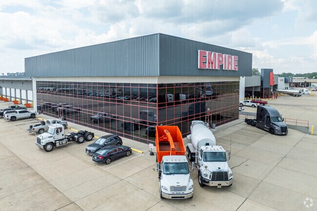
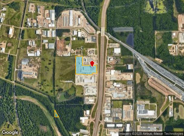
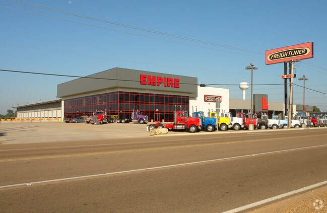
Property Record
373 Highway 49 S, Richland, MS 39218
NEARBY LISTINGS FOR SALE OR LEASE
Property Detail
373 Highway 49 S
D08B-000001-00040
7.825A IN SE4 N/W H/W 49 & 2.95 AC DB 688- 688 PG 0450-0452 0122193 DB 688 PG 0488 0122393 DB 699 PG 0119 0042894
Warehouse
Rankin
AE
Mississippi
28121C0168G
10.77 AC
2024
Outlying Rankin County
2024
Jackson
020402
Jackson, MS
61,637 SF
DEMOGRAPHICS near 373 Highway 49 S
1 Mile
3 Mile
5 Mile
2024 Total Population
290
14,013
73,703
2029 Population
309
14,392
73,509
Pop Growth 2024-2029
+ 6.55%
+ 2.70%
(0.26%)
Average Age
38
38
37
2024 Total Households
113
5,633
27,847
HH Growth 2024-2029
+ 6.19%
+ 2.73%
(0.38%)
Median Household Inc
$7,499
$38,749
$36,516
Avg Household Size
2.60
2.40
2.30
2024 Avg HH Vehicles
2.00
2.00
2.00
Median Home Value
$50,819
$125,682
$93,672
Median Year Built
1985
1977
1969
Nearby Places
Map Layers
Map Styles
 Street
 Aerial
- Restaurants
- Banks
- Shops
- Fitness
- Groceries
PUBLIC TRANSPORTATION
COMMUTER RAIL
Jackson (City of New Orleans - Amtrak)
DRIVE
WALK
Distance
Jackson (City of New Orleans - Amtrak)
11 min
4.9 mi
AIRPORT
Jackson-Medgar Wiley Evers International
DRIVE
WALK
Distance
Jackson-Medgar Wiley Evers International
20 min
10.4 mi
Freight Ports
Port of Greater Baton Rouge
DRIVE
WALK
Distance
Port of Greater Baton Rouge
203 min
178.2 mi
Nearby Properties
Address
Land Use
TOTAL SIZE
Lot Size
Zoning
Address
Land Use
TOTAL SIZE
Lot Size
Zoning
7.60 AC
Address
Land Use
TOTAL SIZE
Lot Size
Zoning
40,148 SF
37.47 AC
Address
Land Use
TOTAL SIZE
Lot Size
Zoning
115,200 SF
0.35 AC
Address
Land Use
TOTAL SIZE
Lot Size
Zoning
58.94 AC
Address
Land Use
TOTAL SIZE
Lot Size
Zoning
123,308 SF
20.88 AC
Address
Land Use
TOTAL SIZE
Lot Size
Zoning
2,190,610 SF
2 AC
Address
Land Use
TOTAL SIZE
Lot Size
Zoning
9,081 SF
0.73 AC
Address
Land Use
TOTAL SIZE
Lot Size
Zoning
55,591 SF
1.01 AC
Address
Land Use
TOTAL SIZE
Lot Size
Zoning
42,520 SF
0.22 AC
Address
Land Use
TOTAL SIZE
Lot Size
Zoning
Address
Land Use
TOTAL SIZE
Lot Size
Zoning
2,348 SF
16.45 AC
Address
Land Use
TOTAL SIZE
Lot Size
Zoning
1,257 SF
2.65 AC
Address
Land Use
TOTAL SIZE
Lot Size
Zoning
8.37 AC
Address
Land Use
TOTAL SIZE
Lot Size
Zoning
Address
Land Use
TOTAL SIZE
Lot Size
Zoning
31,285 SF
2 AC
Address
Land Use
TOTAL SIZE
Lot Size
Zoning
28,216 SF
6 AC
Address
Land Use
TOTAL SIZE
Lot Size
Zoning
139,417 SF
13.50 AC
Address
Land Use
TOTAL SIZE
Lot Size
Zoning
9,632 SF
32.54 AC
Address
Land Use
TOTAL SIZE
Lot Size
Zoning
10,086 SF
2.41 AC
Address
Land Use
TOTAL SIZE
Lot Size
Zoning
253,479 SF
17.08 AC
Address
Land Use
TOTAL SIZE
Lot Size
Zoning
67,442 SF
2.85 AC
Address
Land Use
TOTAL SIZE
Lot Size
Zoning
157,034 SF
17.28 AC
Address
Land Use
TOTAL SIZE
Lot Size
Zoning
1.82 AC
Address
Land Use
TOTAL SIZE
Lot Size
Zoning
80,000 SF
2 AC
Address
Land Use
TOTAL SIZE
Lot Size
Zoning
70,433 SF
2.53 AC
Address
Land Use
TOTAL SIZE
Lot Size
Zoning
7,840 SF
10.34 AC
Address
Land Use
TOTAL SIZE
Lot Size
Zoning
24,081 SF
24.48 AC
Address
Land Use
TOTAL SIZE
Lot Size
Zoning
71,705 SF
11.52 AC
Address
Land Use
TOTAL SIZE
Lot Size
Zoning
58,208 SF
2.41 AC
Address
Land Use
TOTAL SIZE
Lot Size
Zoning
17,128 SF
2 AC
The World's #1 Commercial Real Estate Marketplace
Connect with us
© 2025 CoStar Group
The information above has been obtained from sources believed reliable. While we do not doubt its accuracy we have not verified it and make no guarantee, warranty or representation about it. It is your responsibility to independently confirm its accuracy and completeness. Any projections, opinions, assumptions, or estimates used are for example only and do not represent the current or future performance of the property. The value of this transaction to you depends on tax and other factors which should be evaluated by your tax, financial, and legal advisors. You and your advisors should conduct a careful, independent investigation of the property to determine to your satisfaction the suitability of the property for your needs.